塞拉利昂地理
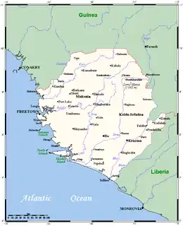
塞拉利昂是一個西非國家,位於非洲西海岸。塞拉利昂在北部及東北部和幾內亞接壤,南部及東南部和利比里亞接壤,西部臨大西洋。 [1]。塞拉利昂的國土面積有71740平方公里,其中土地面積71620平方公里,水域面積120平方公里[2]。塞拉利昂全國可分為四個地理區域。 塞拉利昂大多數地區都是熱帶氣候。
| 塞拉利昂地理 | |
|---|---|
 | |
| 洲 | Africa |
| 地区 | Western Africa |
| 坐标 | 8°30′N 11°30′W |
| 面积 | 第119th名 |
| • 总计 | 71,740平方(27,700平方英里) |
| 海岸线 | 340(210英里) |
| 毗邻 | Guinea, Liberia |
| 最高点 | Mount Bintumani 1,948米(6,391英尺) |
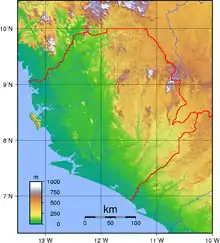
塞拉利昂地形
參考資料
- LeVert, Suzanne. . Marshall Cavendish. 2006: 7 (2007). ISBN 9780761423348.
- . [2012-05-02]. (原始内容存档于2015-10-16).
This article is issued from Wikipedia. The text is licensed under Creative Commons - Attribution - Sharealike. Additional terms may apply for the media files.