塞里约斯河
塞里约斯河(西班牙語:)是美国属土波多黎各龐塞自治市的一条河流,平均流量为24000立方米每秒[6]是龐塞自治市流量第二的河流,仅次于哈卡瓜斯河。
| Cerrillos River 塞里约斯河 | |
|---|---|
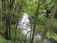 塞里约斯河一景,塞里约斯湖大坝附近 | |
| 流域 | |
| 水系 | Río Bucaná |
| 流向 | 阿农 马拉圭斯 塞里约斯 |
| 源頭 | |
| - 位置 | 阿农村 |
| - 海拔 | 1,200英尺(370)[1] |
| 河口 | 布卡纳河 |
- 海拔 | 69英尺(21)[2] |
| 面積 | 17.80 sq. mi.[3] |
| 流經国家 | 波多黎各 |
| 位置 | 龐塞 |
| 本貌 | |
| 長度 | 18.5英里(29.8)[4] |
| 平均流量 | 24,000 cu ft/s[5] |
| 支流 |
|
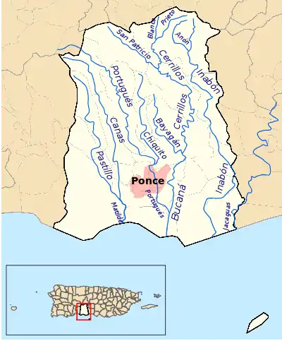
龐塞自治市的水系图,其中粉色的为龐塞城区
另见
- 波多黎各河流列表
参考文献
- Maptest. 的存檔,存档日期2010-02-18. Government of the Commonwealth of Puerto Rico. General Purpose Population Data, Census 2000. Unidad de Sistemas de Información Geográfica, Área de Tecnología de Información Gubernamental, Oficina de Gerencia y Presupuesto. Gobierno de Puerto Rico. Retrieved 24 October 2011.
- Maptest. 的存檔,存档日期2010-02-18. Government of the Commonwealth of Puerto Rico. General Purpose Population Data, Census 2000. Unidad de Sistemas de Información Geográfica, Área de Tecnología de Información Gubernamental, Oficina de Gerencia y Presupuesto. Gobierno de Puerto Rico. Retrieved 24 October 2011.
- Ferdinand Quiñones and Karl G. Johnson. The Floods of May 17-18, 1985 and October 6-7, 1985 in Puerto Rico. U.S. Geological Survey. Open File Report 87-123. Prepared in Conjunction with the Puerto Rico Department of Natural Resources, Puerto Rico Environmental Quality Board, and the Puerto Rico Highway Authority. San Juan, Puerto Rico. 1987. Page 15.
- Projecto Salon Hogar (Estudios Sociales, Puerto Rico, Ponce, Hidrografia). Retrieved August 8, 2009.
- Ferdinand Quiñones and Karl G. Johnson. The Floods of May 17-18, 1985 and October 6-7, 1985 in Puerto Rico. U.S. Geological Survey. Open File Report 87-123. Prepared in Conjunction with the Puerto Rico Department of Natural Resources, Puerto Rico Environmental Quality Board, and the Puerto Rico Highway Authority. San Juan, Puerto Rico. 1987. Page 15.
- Ferdinand Quiñones and Karl G. Johnson. The Floods of May 17-18, 1985 and October 6-7, 1985 in Puerto Rico. U.S. Geological Survey. Open File Report 87-123. Prepared in Conjunction with the Puerto Rico Department of Natural Resources, Puerto Rico Environmental Quality Board, and the Puerto Rico Highway Authority. San Juan, Puerto Rico. 1987. Page 15.
- USGS GNIS: Río Cerrillos
外部链接
- USGS Hydrologic Unit Map – Caribbean Region (1974)
- Rivers of Puerto Rico
- USGS Maps of Municipality of Ponce Rivers, showing Rio Cerrillos and others
This article is issued from Wikipedia. The text is licensed under Creative Commons - Attribution - Sharealike. Additional terms may apply for the media files.