墨西哥湾
墨西哥湾是北美洲南部大西洋的一海湾,以佛罗里达半岛-古巴-猶加敦半岛一线与外海分割。北为美国,南、西为墨西哥,东南为古巴,东经佛罗里达海峡与大西洋相连,经尤卡坦海峡与加勒比海相接,是著名的墨西哥灣暖流的起點。墨西哥湾形成于3亿年前的地球板块运动。[1]
| 墨西哥湾 西班牙語: | |
|---|---|
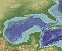 墨西哥湾地图 | |
| 标 | 25°N 90°W |
| 河流源 | 格兰德河, 密西西比河 |
| 海洋源 | 大西洋 |
| 流经国家 | |
| 表面积 | 1,550,000 km2(600,000 sq mi) |
| 定居点 | 休斯顿, 新奥尔良, Tampa, 哈瓦那 |

Cantarell
墨西哥面臨之生態災難
参考资料
- Huerta, A.D., and D.L. Harry (2012) Wilson cycles, tectonic inheritance, and rifting of the North American Gulf of Mexico continental margin. Geosphere. 8(1):GES00725.1, first published on March 6, 2012, doi:10.1130/GES00725.1
This article is issued from Wikipedia. The text is licensed under Creative Commons - Attribution - Sharealike. Additional terms may apply for the media files.