小密苏里河 (密苏里河支流)
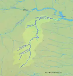
小密苏里河(英語:)是密苏里河的一条支流,长901公里,位于美国大平原的北部[4]。小密苏里河发源于怀俄明州的东北部克魯克縣魔鬼塔以西大约24公里[7],之后流向东北,跨过蒙大拿州东南部的一个角落后进入南达科他州。在南达科塔州,它向北流过荒地进入北达科他州,穿过小密苏里国家草原和西奥多·羅斯福國家公園。在公园北部,它向东流入密苏里州邓恩县的沙卡卡威亞湖,最终在基尔迪尔注入密苏里河。[7]
| 小密苏里河 Little Missouri River | |
 流经西奥多·羅斯福國家公園的小密苏里河 | |
| 国家 | |
|---|---|
| 省/州/邦 | |
| 源头 | Flatiron Butte |
| - 位置 | |
| - 海拔 | 4,501 ft(1,372 m)[1] |
| 河口 | Missouri River[2] |
| - 位置 | |
| - 海拔 | 1,860 ft(567 m)[3] |
| 长度 | 560 mi(901 km)[4] |
| 流域面积 | 8,310 mi²(21,523 km²)[5] |
| 流量 | 沃特福德市以南17.5英里(28.2),距离河口25英里(40)。 |
| - 平均流量 | 534 ft³/s(15 m³/s)[6] |
| - 最大流量 | 110,000 ft³/s(3,115 m³/s) |
| - 最小流量 | 0 ft³/s(0 m³/s) |
 小密苏里河流域
| |
 小密苏里河河口在北达科他州的位置
| |
参考文献
- Source elevation derived from Google Earth search using GNIS source coordinates.
- Federal Writers' Project. . University of South Dakota. 1940: 4.
- Personius, Robert Giles; Eddy, Samuel. . Copeia (American Society of Ichthyologists and Herpetologists). February 18, 1955, 1955 (1): 41. doi:10.2307/1439450.
- . November 2010 [April 27, 2011]. This is only a close approximation of the entire basin. It does not include a small fraction of the basin below the river gauge, located about 25 mi (40 km) upstream of the river mouth.
- . November 2010 [April 27, 2011]. This is the average discharge for the years 1990–2010, derived by adding the discharge for each of these years and dividing by 21.
- (Map) 6th. DeLorme. § 19. 2009. ISBN 0-89933-338-9.
This article is issued from Wikipedia. The text is licensed under Creative Commons - Attribution - Sharealike. Additional terms may apply for the media files.