库特内河
库特内河(英語:或Kootenai[5],也被称作Flatbow[6])是哥伦比亚河的一条重要支流,流经加拿大卑诗省的东南部和美国西北部的爱达荷州与蒙大拿州,全长781(485英里),起源于加拿大落基山脉,在卡斯尔加注入哥伦比亚河,最终注入太平洋。
| 库特内河 Kootenay | |
| Kootenai, Flatbow, Swan | |
| River | |
 库特内河一景,位于蒙大拿州利比大坝下游 | |
| 国家 | |
|---|---|
| 州/省 | |
| 支流 | |
| - 左侧支流 | Palliser River、White River、Bull River、麋鹿河、Fisher River、Tobacco River、Lake Creek |
| - 右侧支流 | St. Mary River、Yaak River、Moyie River、Goat River、Duncan River、Slocan River |
| 城市 | 利比、邦納斯費里、Creston, BC、Nelson, BC、卡斯尔加 |
| 源头 | South flank of Castle Mountain |
| - 位置 | 加拿大卑诗省库特尼国家公园Beaverfoot Range |
| - 海拔 | 2,261 m(7,418 ft)[1] |
| - 坐标 | 51°02′21″N 116°26′33″W [1] |
| 河口 | 哥伦比亚河 |
| - 位置 | 加拿大卑诗省卡斯尔加 |
| - 海拔 | 420 m(1,378 ft)[2] |
| - 坐标 | 49°19′0″N 117°39′4″W |
| 长度 | 780 km(485 mi) |
| 流域面积 | 50,298 km²(19,420 mi²)[2] |
| 流量 | Corra Linn, BC |
| - 平均流量 | 782 m³/s(27,616 ft³/s)[3][4] |
| - 最大流量 | 4,930 m³/s(174,101 ft³/s) |
| - 最小流量 | 104 m³/s(3,673 ft³/s) |
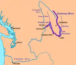 库特内河地图,标出了主要城市与湖泊
| |
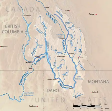
库特内河水系图
参考文献
- Source elevations and coordinates derived from Google Earth using data from Canadian topo maps
- . Balance of Power. 2007 [September 3, 2008]. (原始内容存档于2011年11月6日).
- . HYDAT Archived Hydrometric Data. Environment Canada. 1937–2010 [2011-11-25]. (原始内容存档于2012-04-21).
- . International Alliance for Water Quality and Aquatic Resources. Kootenai River Network, Inc. 2010-03-14 [2010-03-25]. (原始内容存档于2007-09-06).
- USGS GNIS: Kootenai River
- Palliser, John. . G.E. Eyre and W. Spottiswoode for H.M. Stationery Off. 1863: 162.
This article is issued from Wikipedia. The text is licensed under Creative Commons - Attribution - Sharealike. Additional terms may apply for the media files.