斯旺河
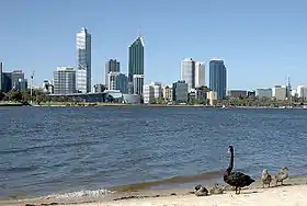
斯旺河(Swan River)是一條流經澳洲西澳大利亞州西南部的河流。在當地原住民的語言中,斯旺河的名稱是Derbarl Yerrigan[2]。斯旺河在伯斯附近入海,其下游河道較寬且水深很深,而上游卻非常狹窄且水深很淺。斯旺河的流域面積約121000平方公里,主要支流有三條,包括了雅芳河、甘寧河和海倫娜河,其中後兩者有攔河壩。斯旺河是伯斯和其附近地區重要的飲用水來源。斯旺河流域的氣候是地中海氣候,冬季溫暖濕潤,夏季炎熱乾燥。流浪因季節降水而大幅變動。斯旺河河口的水位會因潮汐的變動而有約1米的變化。
| Swan | |
| River | |
 [ | |
| 国家 | 澳洲 |
|---|---|
| 省/州/邦 | 西澳大利亞 |
| 支流 | |
| - 左侧支流 | Susannah Brook、Jane Brook |
| - 右侧支流 | Ellen Brook、Helena River、Bennett Brook、Canning River |
| 城市 | 伯斯、弗里曼特爾 |
| 河口 | 印度洋 |
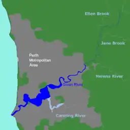 伯斯一帶的斯旺河地圖
| |
| 维基共享资源:Swan River, Western Australia | |
| [1]:3 | |
參考資料
- Middelmann; Rogers; 等. (PDF). Geoscience Australia. Australian Government. June 2005. (原始内容 (PDF)存档于2011-03-17).
- . Swan River Perth. Swan River- Perth. [6 March 2014].
- Burningham, Nick. . Fremantle Arts Centre Press. 2004. ISBN 1-920731-25-3.
- Seddon, George. . University of Western Australia: Printing Press. 1970. ISBN 0-85564-043-X.
- Thompson, James (1911) Improvements to Swan River navigation 1830–1840 [cartographic material] Perth, W.A. : Western Australian Institution of Engineers, 1911. (Perth : Govt. Printer) Battye Library note: – Issued as Drawing no. 1 accompanying Inaugural address by Thompson 31 March 1910 as first president of the Western Australian Institution of Engineers, – Cadastral base map from Lands and Surveys Dept with additions by Thompson showing river engineering works from Burswood to Hierrison [i.e., Heirisson] islands and shorelines as they existed 1830–1840; includes Aboriginal place names along Swan River Estuary.
This article is issued from Wikipedia. The text is licensed under Creative Commons - Attribution - Sharealike. Additional terms may apply for the media files.