沃楚西特礁
沃楚西特礁(Wachusett Reef)是由「沃楚西特」號的船長蘭伯特(Lamber)所回報,在1899年6月4日他穿過了一個暗礁,似乎是由珊瑚礁組成,大約位於32°18′S 151°08′W。該暗礁似乎有500英尺寬。礁石的底部兩側呈現深灰色與深藍色。深度估計約在5至6噚之間,不幸的是沒有探測資料[1]。
| 沃楚西特礁 | |
|---|---|
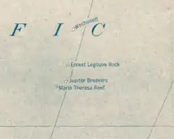 1921年太平洋地圖上的沃楚西特礁 | |
| 类型 | 幽靈島 |
| 知名地点 | 太平洋 |
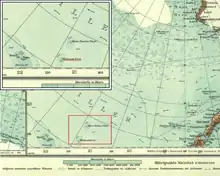
1904年的南極洲地圖上,沃楚西特礁被寫作「沃楚西特沙洲」
1912年歷史性的南極洲地圖上畫有「沃楚西特淺灘」
2005年的「國家地理世界地圖集」仍有畫出沃楚西特礁,深度是9公尺[2]。然而,它的存在令人懷疑。其他歷史上曾經被回報過的附近的暗礁包括埃內斯特-勒古韋礁、木星礁以及瑪麗亞·特里薩礁。
![]() 該條目包含Pacific Islands Pilot, v. 2中的文字,於1916年出版,目前於美國屬於公有領域。
該條目包含Pacific Islands Pilot, v. 2中的文字,於1916年出版,目前於美國屬於公有領域。
參考文獻
- Eade, J.V. (1976). Geological notes on the Southwest Pacific Basin in the area of Wachusett Reef and Maria Theresa Reef. Wellington: New Zealand Oceanographic Institute.
This article is issued from Wikipedia. The text is licensed under Creative Commons - Attribution - Sharealike. Additional terms may apply for the media files.