舍布魯克
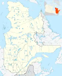
舍布魯克(法語:)是加拿大的一個城市。位於魁北克省西南部。2006年,該市大約有人口15萬人。是艾第地區(法語:)的最大城市。該市早期由说英語的居民居多,但現在已變為法語居民占優。
| 舍布鲁克 | |||||
|---|---|---|---|---|---|
| 县级市镇 | |||||
| 舍布鲁克市镇 Ville de Sherbrooke | |||||
 Wellington Street North | |||||
| |||||
| 綽號:Queen of the Eastern Townships | |||||
| 格言:Ne quid nimis | |||||
 舍布鲁克 地理位置 | |||||
| 坐标:45°24′N 71°54′W[1] | |||||
| 国家 | 加拿大 | ||||
| 省 | 魁北克 | ||||
| 地区 | 艾第区 | ||||
| RCM | None | ||||
| 成立 | 1793 | ||||
| 设立 | 2002年1月1日 | ||||
| 行政区 | 列表
| ||||
| 政府[2] | |||||
| • 类型 | 舍布鲁克市议会 | ||||
| • 市长 | Bernard Sévigny | ||||
| • Federal riding | Compton—Stanstead / Sherbrooke | ||||
| • Prov. riding | Richmond / Saint-François / Sherbrooke | ||||
| 面积[2][3] | |||||
| • 县级市镇 | 367.10 平方公里 (141.74 平方英里) | ||||
| • 陸地 | 353.49 平方公里(136.48 平方英里) | ||||
| • 市區[4] | 171.04 平方公里(66.04 平方英里) | ||||
| • 都會區[5] | 1,459.61 平方公里(563.56 平方英里) | ||||
| 最高海拔 | 378 米(1,240 英尺) | ||||
| 最低海拔 | 128 米(420 英尺) | ||||
| 人口(2011)[3] | |||||
| • 县级市镇 | 154,601人 | ||||
| • 密度 | 437.4人/平方公里(1,133人/平方英里) | ||||
| • 市区[4] | 140,628 | ||||
| • 市区密度 | 822.2人/平方公里(2,129人/平方英里) | ||||
| • 都會區[5] | 201,890 | ||||
| • 都會區密度 | 138.3人/平方公里(358人/平方英里) | ||||
| • Pop 2006–2011 | ▲ 4.9% | ||||
| • Dwellings | 75,880 | ||||
| 时区 | EST(UTC−5) | ||||
| • 夏时制 | EDT(UTC−4) | ||||
| 邮政编码 | J1E to J1R | ||||
| 電話區號 | 819 | ||||
| 电话号段 | -212 239 340 345-9 432 434 437 446 542 560 -6 569 570 - 4 575 577 | ||||
| GNBC Code | EIDHN | ||||
| NTS Map | 021E05 | ||||
| 網站 | www | ||||
.svg.png.webp)
参考
- Reference number 59493 of the Commission de toponymie du Québec (法文)
- Template:Mamrot
- . Canada 2011 Census. Statistics Canada. 8 February 2012 [9 February 2012].
- . Canada 2011 Census. Statistics Canada. 6 June 2012 [29 July 2012].
- . Canada 2011 Census. Statistics Canada. 9 February 2012 [9 February 2012].. The census metropolitan area consists of Sherbrooke, Ascot Corner, Compton, Hatley (township), Magog, North Hatley, Orford, Saint-Denis-de-Brompton, Stoke, Val-Joli, Waterville. In the 2006 census, the census metropolitan area had not included Orford and Val-Joli.
外部链接
| 维基共享资源中相关的多媒体资源:舍布魯克 |
- (英文) (法文) 舍布鲁克市公所 页面存档备份,存于
- (法文) La Tribune
- (英文) The Record - English language daily newspaper 页面存档备份,存于
- (英文) The Townships Outlet - English language bi-monthly newspaper)
This article is issued from Wikipedia. The text is licensed under Creative Commons - Attribution - Sharealike. Additional terms may apply for the media files.