范登博斯陨石坑
范登博斯陨石坑(Van den Bos)是位于月球背面赤道区的一座撞击坑,其名称取自荷兰裔南非天文学家"威廉 ·亨德里克·范登博斯"(Willem Hendrik van den Bos,1896年-1974年),1979年被国际天文学联合会正式批准接受。
| 范登博斯陨石坑 | |
|---|---|
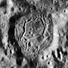 月球轨道器1号拍摄的图像 | |
| 纬度 | 5.26°S |
| 经度 | 145.95°E |
| 直径 | 25.2公里 |
| 深度 | 1.8公里 |
| 月面座標 | 日出时214° |
| 命名来源 | 威廉·亨·范登博斯 |
描述
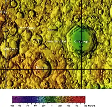
范登博斯陨石坑周边图,月球背面详图[1]
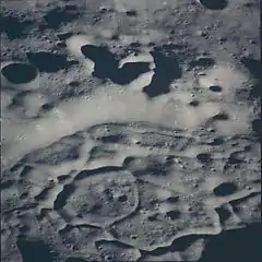
阿波罗14号拍摄的东南向斜视图
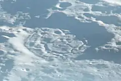
阿波罗12号拍摄的南向斜视图
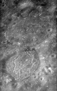
该陨坑西侧毗邻维尔耶夫陨石坑;东北与塔姆陨石坑相接壤;东侧坐落着恰普雷金环形山;马可尼环形山横亘在它的南面[2]。 该环形山的中心月面坐标为5.26°S 145.95°E,直径25.2公里[3],深度1.8公里[4]。
该陨坑相对较浅,坑壁磨损度中等。其东北侧长达15公里的外侧壁与相邻的塔姆陨坑合在一起;陨坑壁平均高出周边地形810米[4],内部容积约300公里3[4]。碗状的坑底相对平坦,表面布满了一系列纵横交错的沟壑,这些沟壑通常为玄武岩熔岩的冷却收缩所导致。之前它们曾被推测为西北225公里处门捷列夫盆地溅射在塔姆坑和范登博斯坑内的黏性撞击融熔物所形成的裂缝[5]。
参考文献
- Map the reverse side of the moon
- Crater Van den Bos on LAC-84 map
- Directory of the International Astronomical Union
- Lunar Impact Crater Database
- The geologic history of the Moon, 1987, Wilhelms, Don E.; with sections by McCauley, John F.; Trask, Newell J. USGS Professional Paper: 1348. (online), Figure 6.13 H
另请参阅
- Andersson, L. E.; Whitaker, E. A. . NASA RP-1097. 1982.
- Blue, Jennifer. . USGS. July 25, 2007 [2007-08-05].
- Bussey, B.; Spudis, P. . New York: Cambridge University Press. 2004. ISBN 978-0-521-81528-4.
- Cocks, Elijah E.; Cocks, Josiah C. . Tudor Publishers. 1995. ISBN 978-0-936389-27-1.
- McDowell, Jonathan. . Jonathan's Space Report. July 15, 2007 [2007-10-24].
- Menzel, D. H.; Minnaert, M.; Levin, B.; Dollfus, A.; Bell, B. . Space Science Reviews. 1971, 12 (2): 136–186. Bibcode:1971SSRv...12..136M. doi:10.1007/BF00171763.
- Moore, Patrick. . Sterling Publishing Co. 2001. ISBN 978-0-304-35469-6.
- Price, Fred W. . Cambridge University Press. 1988. ISBN 978-0-521-33500-3.
- Rükl, Antonín. . Kalmbach Books. 1990. ISBN 978-0-913135-17-4.
- Webb, Rev. T. W. 6th revised. Dover. 1962. ISBN 978-0-486-20917-3.
- Whitaker, Ewen A. . Cambridge University Press. 1999. ISBN 978-0-521-62248-6.
- Wlasuk, Peter T. . Springer. 2000. ISBN 978-1-85233-193-1.
外部链接
This article is issued from Wikipedia. The text is licensed under Creative Commons - Attribution - Sharealike. Additional terms may apply for the media files.