马塔努斯卡河
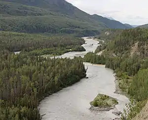
马塔努斯卡河(英語:,德納伊納語:Ch'atanhtnu)是美国阿拉斯加中南部一条长75英里(121公里)的河流。河流流经阿拉斯加山脈南部的一条宽阔的山谷,該山谷的名字為马塔努斯卡山谷[6]。
| 马塔努斯卡河 Matanuska River | |
|---|---|
 | |
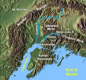 南阿拉斯加,位於安克拉治附近 | |
 马塔努斯卡河口的位置 | |
| 國家 | 美国 |
| 州 | 阿拉斯加州 |
| 自治市镇 | 馬塔努斯卡-蘇西特納自治市鎮 |
| 流域 | |
| 源頭 | |
| - 坐標 | 61°47′27″N 147°29′07″W[1] |
| - 海拔 | 2,033英尺(620米)[2] |
| 河口 | 库克湾尼克·阿姆 |
- 位置 | 帕尔默西南9.5英里(15.3) |
- 坐標 | 61°29′49″N 149°16′11″W[1] |
- 海拔 | 0英尺(0米)[1] |
| 面積 | 2,100 sq mi(5,400 km2)[3] |
| 本貌 | |
| 長度 | 75 mi(121 km)[4] |
| 流量 | |
参考文献
- . Geographic Names Information System. United States Geological Survey. March 31, 1981 [December 5, 2013].
- Derived by entering source coordinates in Google地球.
- Curran, J. H.; McTeague, M. L. (PDF). U.S. Geological Survey: 1–5. 2011 [December 5, 2013].
- Orth, Donald J.; United States Geological Survey. (PDF). University of Alaska Fairbanks. United States Government Printing Office. 1971: 628 [1967] [December 5, 2013]. (原始内容 (PDF)存档于October 17, 2013). 已忽略未知参数
|url-status=(帮助) - . United States Geological Survey. [December 6, 2013].
- 7th. Yarmouth, Maine: DeLorme. 2010: 83–84. ISBN 978-0-89933-289-5.
This article is issued from Wikipedia. The text is licensed under Creative Commons - Attribution - Sharealike. Additional terms may apply for the media files.