上西城
上西城(英語:)是美国纽约市曼哈顿的一片街区,介于中央公园与哈德逊河之间,西59街以上。常简稱為UWS。
| 上西城 Upper West Side | |
|---|---|
| 曼哈頓街區 | |
 | |
| 綽號:UWS | |

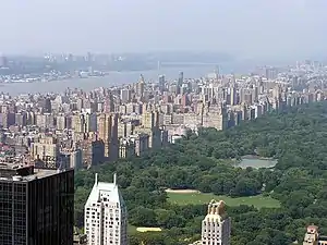
Location in New York City | |
| 坐标:40.787°N 73.975°W | |
| 國家 | |
| 州份 | |
| 城市 | 紐約市 |
| 行政區 | 曼哈頓 |
| 社區 | 7區[1] |
| 面积[1] | |
| • 总计 | 5 平方公里(1.9 平方英里) |
| 人口(2018)[1] | |
| • 總計 | 214,744人 |
| 種族[1] | |
| • 白人 | 67.4% |
| • 拉丁裔 | 15.0 |
| • 黑人 | 7.6 |
| • 亞裔 | 7.6 |
| • 其他 | 2.4 |
| 經濟[2] | |
| • 收入中位數 | $121,032 |
| 时区 | 东部时区(UTC−5) |
| • 夏时制 | EDT(UTC−4) |
| 郵區編號 | 10023, 10024, 10025, 10069 |
| 電話區號 | 212, 332, 646, and 917 |
地理
上西区南到59街,东到中央公园,西到哈德逊河,北到110街,完全毗邻中央公园。 [3]
自西向东,上西区的大道有河滨大道(第十一大道)、百老汇、阿姆斯特丹大道(第十大道)、哥伦布大道(第九大道)、曼哈顿大道和中央公园西(第八大道)。
参考文献
- . communityprofiles.planning.nyc.gov. New York City Department of City Planning. [March 18, 2019]. (原始内容存档于2019-03-24).
- . [March 18, 2019]. (原始内容存档于2020-09-17).
- [Waxman, Sarah. "The History of the Upper West Side" Archived 2012-10-31 at WebCite, NY.com. Acecssed 2007-07-07. "Home to such venerable New York landmarks as Lincoln Center, Columbia University, the Cathedral of St. John the Divine, the Dakota Apartments, and Zabar's food emporium, the Upper West Side stretches from 59th Street to 125th Street, including Morningside Heights. It is bounded by Central Park on the east and the Hudson River on the west."
伸延閲讀
- Hopper Striker Mott, The New York of Yesterday: A Descriptive Narrative of Old Bloomingdale, 1908。
- Peter Salwen, Upper West Side Story页面存档备份,存于 1989,ISBN 0-89659-894-2.
- Steven Birmingham, Life at the Dakota: New York's Most Unusual Address, 1996,ISBN 0-8156-0338-X.
外部連結
| 維基導遊上的相關旅行指南:Upper West Side |
| 维基共享资源中相关的多媒体资源:上西城 |
- Broadway Mall Association
- Landmark West!页面存档备份,存于
- NYCvisit Upper West Side map页面存档备份,存于
- NYSite Upper West Site Guide页面存档备份,存于 including the block by block guide
- NYU – Historical Architecture of the Upper West Side页面存档备份,存于
- 上西城歷史&回憶錄页面存档备份,存于
相關條目
- 上東城
This article is issued from Wikipedia. The text is licensed under Creative Commons - Attribution - Sharealike. Additional terms may apply for the media files.
