中国塔吉克斯坦边界

历史


1864年俄罗斯帝国与清朝签订的《塔城界约》[3][4][5][6][4],规定中俄边界“行至葱岭,靠浩罕界为界”,实际上未涉及塔吉克地段的边界。1881年签订的《中俄伊犁条约》规定中俄两国在帕米尔的边界线“照两国现管之界勘定”。1884年勘界和签订《中俄续勘喀什噶尔界约》[4][4],中俄两国在帕米尔地区分界线的起点从帕米尔北部的阿赖岭移到了东北部的乌孜别里山口并规定从乌孜别里山口往南,“俄国界线转向西南,中国界线一直往南”,中间形成一块“待议区”。大英帝国与俄罗斯帝国争夺中亚控制之大博弈,1890年签订英俄协定。1891年,沙俄出兵帕米尔进入“待议区”。1892年进入“中国界线一直往南”这条中国边界以东的中国领土。1895年3月11日,英俄签订了《关于帕米尔地区势力范围的协议》[4],划定两国在帕米尔的势力分界线,将兴都库什山北麓与帕米尔南缘之间的狭长地带划作两国间的隔离带,这条缓冲地带就是瓦罕走廊。1895年7月,俄英两国开始在帕米尔地区进行勘界活动。清政府在帕米尔划界问题上坚持原则立场:帕米尔属于中国,不承认沙俄派兵强占并同英国瓜分帕米尔的行为。
1999年中华人民共和国和塔吉克斯坦共和国签署了《中塔国界协定》,划分了乌孜别里山口以北的中国塔吉克斯坦边界。2000年7月,中塔吉三国签署了《中塔吉关于三国国界交界点的协定》。2002年5月27日签订《中华人民共和国和塔吉克斯坦共和国关于中塔国界的补充协定》,划分了乌孜别里山口以南的中国塔吉克斯坦边界。2011年塔吉克斯坦批准了1999年与2002年的两个边界协定。[7]
地理
中塔国界第四号界点(位于玛尔坎苏河水流中心线)是中国最西端。
阿富汗-中国-塔吉克斯坦三国国界交界点为海拔5698m的克克拉去考勒峰[8][9][10][11](苏联地图为海拔5518.5m的波瓦洛--什韦科夫斯基峰[12])。这也是阿富汗的最东点。
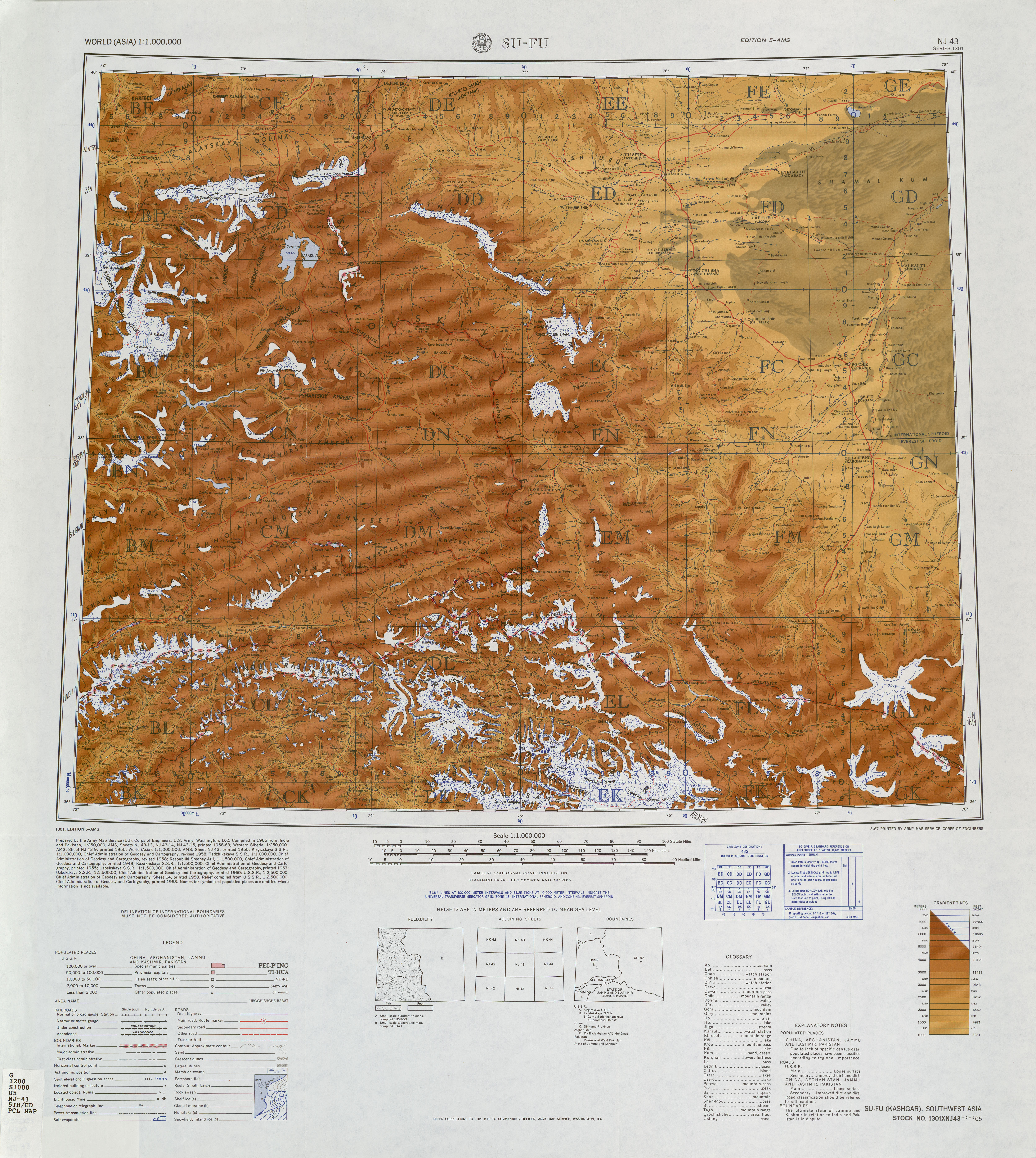
中塔边界的唯一公路口岸为库利马口岸,中方称卡拉苏口岸,阔勒买大坂海拔4,362.7米(14,313英尺)。[13]
历史上,更南的奈扎塔什山隘(海拔4476米)与克克敖吊克大坂(苏联称别伊克山口,海拔4742.0米)也可以翻越萨雷阔勒岭。
中塔边界西北部的通道有乌孜别里山口[8] ([14][15](苏联称Pereval Kyzyl-Dzhiik[16][17])等。
地图
以下为20世纪中叶中苏国界塔吉克地段的地图:

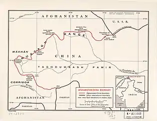 中国阿富汗国界(含阿富汗-中国-苏联三国国界交界点标记为PEAK POVALO SHVEIKOVSKI 5698 (18694)) (1969)[lower-alpha 2]
 中苏边界帕米尔地区(41,000 km2(16,000 sq mi))中方主张
 边界地区(DMA, 1980)[lower-alpha 3]
 边界的北部/西部(DMA, 1981)[lower-alpha 4]
 边界的南部/东部(DMA, 1984)[lower-alpha 5]
 中苏国界(塔吉克地段)(DMA, 1988)[lower-alpha 6]
 中塔边界(DMA, 1992)[lower-alpha 7]
 中塔边界,公路通过库利马口岸(中方为卡拉苏口岸) (2001)
 中塔边界
中塔边界
注释
- From map: "DELINEATION OF INTERNATIONAL BOUNDARIES MUST NOT BE CONSIDERED AUTHORITATIVE"
- From map: "NAMES AND BOUNDARY REPRESENTATION ARE NOT NECESSARILY AUTHORITATIVE"
- From map: "The representation of international boundaries is not necessarily authoritative."
- From map: "The representation of international boundaries is not necessarily authoritative"
- From map: "The representation of international boundaries is not necessarily authoritative"
- From map: "THE REPRESENTATION OF INTERNATIONAL BOUNDARIES IS NOT NECESSARILY AUTHORITATIVE."
- From map: "BOUNDARY REPRESENTATION IS NOT NECESSARILY AUTHORITATIVE."
参考文献
| 维基共享资源中相关的多媒体资源:中国塔吉克斯坦边界 |
| 中文维基文库中与本条目相关的原始文献: |
| 中文维基文库中与本条目相关的原始文献: |
- . The World Factbook. [30 January 2020].
China total: 22,457 km border countries (15):{...}Tajikistan 477 km, {...}Tajikistan total: 4,130 km border countries (4): {...}China 477 km, {...
} - , 23 September 2018
- Articles 2 and 3 in the Russian text of the treaty
- (PDF), 13 February 1978 [23 September 2018]
- (See the map)
- . [2020-03-06]. (原始内容存档于2015-03-13).
- Alex Sodiqov. . Eurasia Daily Monitor (Jamestown Foundation). 24 January 2011, 8 (16) [23 September 2018].
On January 12, the lower house of the Tajik parliament voted to ratify the 2002 border demarcation agreement, handing over 1,122 square kilometers (433 square miles) of mountainous land in the remote Pamir Mountains (www.asiaplus.tj, January 12). The ceded land represents about 0.8 percent of the country’s total area of 143,100 square kilometers (55,250 square miles).{...}At the time of independence, Tajikistan inherited three disputed border segments, constituting about 28,500 square kilometers (11,000 square miles), which China and the Soviet Union had been unable to resolve. In 1999, Tajikistan and China signed a border demarcation agreement, defining the border in two of the three segments. Under the 1999 deal, Dushanbe ceded about 200 square kilometers (77 square miles) of land to Beijing (http://www.ca-oasis.info/oasis/?jrn=109&id=817).
- (PDF). United States Joint Publications Research Service: 1. 18 November 1982 [11 January 2020]. (原始内容存档 (PDF)于2020-01-11) –Defense Technical Information Center.
If we open up the Atlas of the People's Republic of China we will find that the region of the Pamir, the western extremity of Xinjiang, from the Wuzibieli [Uzbel] Pass1 to the south down to the Kekelaqukaole Peak (which the Soviet Russians call "Pavel Shveikovsky Peak") is designated as a not limited area.
- . State Ethnic Affairs Commission. 6 July 2004. (原始内容存档于4 December 2008) (中文(简体)).
- Kamoludin Abdullaev. 3. Rowman & Littlefield. 2018: 92. ISBN 9781538102527 –Google Books.
CHINA-TAJIK BORDER.{...}This mountainous boundary runs along the Sarikol mountain range in eastern Tajikistan, reaching in Pamir the Afghan border at the Povalo-Shveikovskogo peak (5,543 meters above sea level).
- . Washington, D. C.: Army Map Service. March 1967 [2020-03-06]. (原始内容存档于2019-10-13) –Perry–Castañeda Library Map Collection (英语).
Pik Povalo-Shveikovskogo
- . 22 November 1963 [2020-12-12]. (原始内容存档于2020-11-04) –Wikisource (中文).
- , [23 September 2018], (原始内容存档于2020-07-01)
- 夏征农; 陈至立 (编). [Cihai (Sixth Edition in Color)]. 上海. Shanghai: 上海辞书出版社. Shanghai Lexicographical Publishing House. September 2009: 2187. ISBN 9787532628599 (中文).
- Uzbel Shankou (Approved - N)位于GEOnet名称服务器的结果, United States National Geospatial-Intelligence Agency
- Pereval Kyzyl-Dzhiik (Approved - N)位于GEOnet名称服务器的结果, United States National Geospatial-Intelligence Agency
- . [2020-03-06]. (原始内容存档于2020-01-16) –Library of Congress.
Wu-tzu-pieh-li Shan-k'ou (Pereval Kyzyl-Dzhiik)
