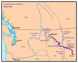
克拉克福克河
| 克拉克福克河 Clark Fork | |
| Original name given by Lewis and Clark expedition: Clark's Fork of the Missoula | |
| River | |
 克拉克福克河一景,位于蒙大拿州米蘇拉 | |
| 国家 | |
|---|---|
| 省/州/邦 | |
| 支流 | |
| - 左侧支流 | Bitterroot River |
| - 右侧支流 | 布莱克富特河、Flathead River、Bull River |
| 城市 | 比尤特、米蘇拉 |
| 源头 | 银弓溪 |
| - 位置 | 蒙大拿州銀弓縣比尤特 |
| - 海拔 | 6,882 ft(2,098 m)[1] |
| - 坐标 | 46°4′32″N 112°27′56″W [2] |
| 次源 | Warm Springs Creek |
| - 位置 | 蒙大拿州格拉尼特縣Flint Creek Range |
| - 海拔 | 7,466 ft(2,276 m)[3] |
| - 坐标 | 46°15′39″N 113°8′12″W [4] |
| 汇合点 | |
| - 位置 | 蒙大拿州鹿棧縣 |
| - 海拔 | 4,795 ft(1,462 m)[5] |
| - 坐标 | 46°11′12″N 112°46′18″W [6] |
| 河口 | 庞多雷湖 |
| - 位置 | 爱达荷州邦納縣 |
| - 海拔 | 2,064 ft(629 m)[7] |
| - 坐标 | 48°11′0″N 116°16′9″W [6] |
| 长度 | 310 mi(499 km)[6] |
| 流域面积 | 22,905 mi²(59,324 km²)[8] |
| 流量 | Whitehorse Rapids near Cabinet, ID |
| - 平均流量 | 21,930 ft³/s(621 m³/s)[9] |
| - 最大流量 | 195,000 ft³/s(5,522 m³/s) |
| - 最小流量 | 762 ft³/s(22 m³/s) |
延伸阅读
- Sullivan, Gordon. . Woodstock, VT: The Countryman Press. 2008. ISBN 978-0-88150-679-2.
参考文献
- Google Earth elevation for GNIS Silver Bow Creek source coordinates.
- . 美国地质局地理名称信息系统., USGS GNIS.
- Google Earth elevation for GNIS Warm Springs Creek source coordinates.
- . 美国地质局地理名称信息系统., USGS GNIS.
- Google Earth elevation for GNIS Clark Fork source coordinates.
- . 美国地质局地理名称信息系统., USGS GNIS.
- Google Earth elevation for GNIS Clark Fork mouth coordinates.
- (PDF). [2014-07-09]. (原始内容 (PDF)存档于2012-12-11)., Northwest Power and Conservation Council.
- . [2014-07-09]. (原始内容存档于2012-12-11)., file (PDF). [2014-07-09]. (原始内容存档 (PDF)于2012-12-11)..
This article is issued from Wikipedia. The text is licensed under Creative Commons - Attribution - Sharealike. Additional terms may apply for the media files.

