內華達山脈 (美國)
內華達山脈(英語:),中文又音谢拉内华达,雪樂山是一條縱貫美國加利福尼亞州東部的山脈。部分山體也位於內華達州境內。內華達山脈的最高峰是惠特尼峰,標高4,418 m。優勝美地國家公園的大部分區域都位於內華達山脈內。內華達山脈內有塔霍湖等湖泊。macOS Sierra用了該名。
| Sierra Nevada 內華達山脈 | |
|---|---|
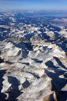 The Sierra's Mills Creek cirque (center) is on the west side of the Sierra Crest, south of Mono Lake (top, blue). | |
| 最高点 | |
| 山峰 | 惠特尼峰(Mount Whitney) |
| 海拔 | 14,505英尺(4,421) [1] |
| 36°34′43″N 118°17′31″W | |
| 规模 | |
| 长度 | 400英里(640) north-south from Fredonyer Pass to Tehachapi Pass [2] |
| 宽度 | 65英里(105) [3] |
| 面积 | 24,370平方英里(63,100平方) [4] |
| 命名 | |
| 语源 | 1777: Spanish for "snowy mountain range" |
| 昵称 | the Sierra, the High Sierra, Range of Light (1894, John Muir)[5] |
| 地理 | |
 Position of Sierra Nevada inside California
| |
| 国家 | 美國 |
| 州 | 加利福尼亞州和內華達州 |
| 距離坐標 | 37°43′51″N 119°34′22″W |
| 地质 | |
| 岩石年代 | Mesozoic |
| 岩石类型 | batholith和igneous |
This article is issued from Wikipedia. The text is licensed under Creative Commons - Attribution - Sharealike. Additional terms may apply for the media files.