塞浦路斯行政区划
| 塞浦路斯地区行政区划 Kıbrıs'ın kazaları (土耳其语) Επαρχίες της Κύπρου (希腊语) | |
|---|---|
 | |
| 分類 | 单一制国家结构形式 |
| 位置 | 塞浦路斯共和国 |
| 數量 | 6 区 |
| 人口 | 没有数据 |
| 面積 | 数据不足 |
| 本级政府 | 区政府,国家政府 |
| 下級 | 塞浦路斯直辖市 |
塞浦路斯行政区划
%252C_administrative_divisions_-_Nmbrs_-_colored.svg.png.webp)
南塞浦路斯行政區劃
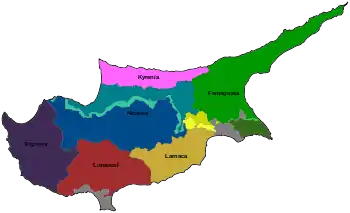
行政区划
| 大区 | 人口 (2011 census)[1] | 面积 (km2)[2] |
|---|---|---|
| 法马古斯塔区 (; ) | 47,338 | 1,985.3 |
| 凯里尼亚区 (; ) | N/A | 643.9 |
| 拉纳卡区 (; ) | 145,365 | 1,120.1 |
| 利马索尔区 (; or ) | 239,842 | 1,393.3 |
| 南尼科西亚区 (; ) | 334,120 | 2,710.0 |
| 帕福斯区 (; or ) | 90,295 | 1,389.8 |
參見
參考資料
- Cyprus Statistical Service Population Figures — Adjusted values.
- Cyprus Statistical Service Classifications — Degree of Urbanization.
外部連結
- CityMayors article
- Cyprus at geo.webnabor.com
This article is issued from Wikipedia. The text is licensed under Creative Commons - Attribution - Sharealike. Additional terms may apply for the media files.
