拉普拉塔河
拉普拉塔河(西班牙語:),实际上是南美洲巴拉那河和乌拉圭河汇集后形成的一个河口湾。其名在西班牙语中意为“白银之河”。
| Río de la Plata 拉普拉塔河 | |
|---|---|
 | |
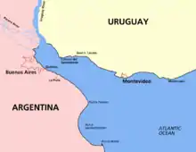
 Map of the Río de la Plata basin, showing the Río de la Plata at the mouths of the Paraná and Uruguay rivers, near Buenos Aires | |
| 别名 | River Plate, La Plata River |
| 國家 | |
| 城市 | La Plata, Buenos Aires, Montevideo, San Fernando, San Isidro, Vicente López, Avellaneda, Quilmes, Berazategui, Hudson, Punta Lara, Atalaya, San Clemente del Tuyú, Ciudad del Plata, Ciudad de la Costa, Colonia del Sacramento |
| 流域 | |
| 源頭 | Confluence of Paraná and Uruguay Rivers |
| - 位置 | 阿根廷和乌拉圭之间 |
| - 坐標 | 34°0′5″S 58°23′37″W[1] |
| 河口 | 大西洋 |
- 位置 | 阿根庭海 |
- 坐標 | 35°40′S 55°47′W[2] |
| 面積 | 3,170,000 km2(1,220,000 sq mi)[3] |
| 本貌 | |
| 長度 | 290 km(180 mi)[4] 4,876 km(3,030 mi) including the Paraná |
| 流量 |
|
| 特徵 | |
| 支流 | |
地图
拉普拉塔河位于南美洲东南部阿根廷和乌拉圭之间,河长約290公里,其宽度从西端两河汇集处的48公里逐渐扩大至东部与大西洋相交处的220公里,最宽处约达290公里,是世界上最宽的河口。西北段因受大量河水注入,为淡水;东南段因海洋影响,为咸水。阿根廷首都布宜诺斯艾利斯位于拉普拉塔河西南岸,乌拉圭首都蒙得维的亚则位于东北岸处。
参考资料
- Rela, Walter. España en el Río de la Plata: Descubrimiento y Poblamientos (1516-1588). Montevideo: Club Español. 2001. ISBN 9974-39-317-5.
- Simionato, Claudia G., Vera, Carolina S., Siegismund, Frank (2005). "Surface Wind Variability on Seasonal and Interannual Scales Over Río de la Plata Area" Journal of Coastal Research. 21 (4): 770-783. 摘要
外部链接
- Treaty between Uruguay and Argentina concerning the Rio de la Plata and the Corresponding Maritime Boundary (19 November 1973) 页面存档备份,存于
- 巴拉圭或拉普拉塔河省,及其毗邻的图卡门与圣克鲁斯·德拉·谢拉地区 页面存档备份,存于
- Río Paraná Guazú位于GEOnet名称服务器的结果 (main distributary of the Río Paraná)
- Raúl A. Guerrero; 等. . Continental Shelf Research. June 1997, 17 (7): 727–742. Bibcode:1997CSR....17..727G. doi:10.1016/S0278-4343(96)00061-1.
- . . [11 August 2010]. (原始内容存档于9 May 2015). 已忽略未知参数
|url-status=(帮助)
This article is issued from Wikipedia. The text is licensed under Creative Commons - Attribution - Sharealike. Additional terms may apply for the media files.
