燭臺雙嶼

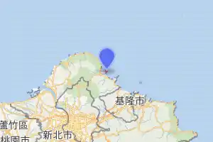
地形
本為金山岬的一部分,後因板塊運動與海風侵蝕,使其岬角分開,下方的海蝕洞逐漸貫穿成海岬,形成類似石門的海拱,之後海拱頂部崩塌,形成兩座海石柱形的顯礁,如兩座燭臺[2]。
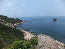
旅客可從獅頭山公園觀賞,是北海十二景之一,也是台灣北部地區有名的拍攝景點[3]。
參考
This article is issued from Wikipedia. The text is licensed under Creative Commons - Attribution - Sharealike. Additional terms may apply for the media files.
