狄阿克里亚区
狄阿克里亚区(英語:)是美国地质调查局太空地质学研究计划(Astrogeology Research Program)对火星表面划分的30个区域之一,编号为MC-2。狄阿克里亚区位于火星西半球的西北部,覆盖了火星东经180°至240°(西经120°至180°)、北纬30°至65°的区域。该区域使用1:5,000,000比例尺的朗伯等角圆锥投影。[1]
| 狄阿克里亚区 | |
|---|---|
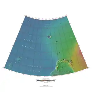 | |
狄阿克里亚区的南北边界分别为大约3,065公里与1,500公里宽,南北距离则为约2,050公里。[2]覆盖范围约为490万平方公里,占火星表面积的3%以上。[3]凤凰号火星探测器的着陆点(68.22° N, 234.25° E)位于狄阿克里亚区东北部往北约186公里处。凤凰号拍摄到的景像包括了狄阿克里亚区北部代表性的地形。
参考文献
| 维基共享资源中相关的多媒体资源:狄阿克里亚区 |
- Davies, M.E.; Batson, R.M.; Wu, S.S.C. "Geodesy and Cartography" in Kieffer, H.H.; Jakosky, B.M.; Snyder, C.W.; Matthews, M.S., Eds. Mars. University of Arizona Press: Tucson, 1992.
- Distances calculated using NASA World Wind measuring tool. http://worldwind.arc.nasa.gov/ 页面存档备份,存于.
- Approximated by integrating latitudinal strips with area of R^2 (L1-L2)(cos(A)dA) from 30° to 65° latitude; where R = 3889 km, A is latitude, and angles expressed in radians. See: http://stackoverflow.com/questions/1340223/calculating-area-enclosed-by-arbitrary-polygon-on-earths-surface.
This article is issued from Wikipedia. The text is licensed under Creative Commons - Attribution - Sharealike. Additional terms may apply for the media files.
