馬尼拉海溝
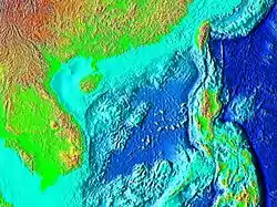
馬尼拉海溝(英語:)是位在菲律賓西方南海的海溝,最深處約5,400公尺[1]。而南海的平均深度約1,500公尺。馬尼拉海溝是中國中沙群島與菲律賓群島的自然地理分界。

地質狀態

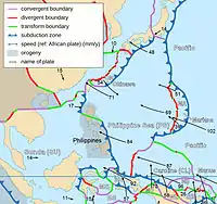
馬尼拉海溝是由隱沒帶造成,歐亞板塊在此沒入菲律賓活動帶之下。
馬尼拉海溝周圍發生過許多地震,而板塊運動更使菲律賓呂宋島西側的火山弧中的火山受到抬升,其中包括皮纳图博火山。
巽他板塊(歐亞大陸板塊一部份)沒入呂宋火山島弧之下,產生了幾乎正南北走向的海溝。這條海溝北起台灣碰撞帶,南至民都洛地体(蘇祿-巴拉望地塊和呂宋島西南相撞擊)。這個區域有負值的重力异常現象(Hayes and Lewis, 1984)。
菲律賓活動帶和馬尼拉海溝的匯合活動已經使用全球定位系統進行量測,在台灣是每年移動50公釐,而呂宋島北部附近每年移動100公釐,三描禮士省附近每年移動約50公釐,民都洛附近每年移動約20公釐(Rangin et al., 1999; Galgana et al., 2007)。巽他板塊和呂宋島之間只有約1%是互相鎖定的,幾乎所有未鎖定的部份被認為是彈性地塊模式,該海溝因此被認為吸收了許多菲律賓碰撞帶和歐亞大陸板塊之間的能量(Kreemer et al., 2001; Galgana et al., 2007)。
可能海嘯威脅
2007年12月5日國立中央大學水文與海洋科學研究所吳祚任教授指出,馬尼拉海溝可能是引發海嘯的高危險區域,如有規模8.0以上地震在此地發生,台灣西南部沿海和廣東、香港、越南等地將會受到海嘯威脅[2][3][4][5]。2011年3月11日日本發生規模9.0的大地震引發大海嘯後,馬尼拉海溝再度受到台灣學界和官方重視[6][7][8][9]。而國立中央大學地球科學系馬國鳳教授則指出馬尼拉海溝走向與台灣西南部海岸線垂直,會限制地震波和海嘯對台灣西南部的破壞程度[10]。
参考文献
引用
- Liu, Y.; Angela Santos; Shuo M. Wang; Yaolin Shi; Hailing Liu; David A. Yuen (2007). Tsunami hazards along Chinese coast from potential earthquakes in South China Sea 页面存档备份,存于 (preprint), Physics of The Earth and Planetary Interiors, 163 (1-4), 233–244. doi:10.1016/j.pepi.2007.02.012.
- 馬尼拉海溝若強震 大海嘯襲台 的存檔,存档日期2013-10-09.
- 專家指下個強震可能在高屏 馬尼拉海溝釋能量恐致大海嘯
- 中大研究 馬尼拉海溝若地震 大海嘯直衝台灣西南 的存檔,存档日期2011-03-16.
- 台灣海嘯危機 點名馬尼拉海溝 的存檔,存档日期2015-06-03.
- 馬尼拉海溝強震若引發海嘯 南台灣精華區將全毀
- 陳冠宇:馬尼拉海溝可能造成兩岸海嘯
- 李錫堤:台灣不會發生規模9地震 因為斷層需長600公里
- . [2011-04-17]. (原始内容存档于2011-04-19).
- 超級大地震,可能在台灣? 页面存档备份,存于《新新聞》第1254期
来源
- 书籍
- Bowin, C., R.S. Lu, C.S. Lee and H. Schouten (1978) Plate convergence and accretion in Taiwan-Luzon region, Am. Assoc. Pet. Geol. Bull 62: 1645-1672
- Hayes, D.E. and S.D. Lewis (1984) A geophysical study of the Manila trench, Luzon, Philippines. 1. Crustal structure, gravity and regional tectonic evolution, J. Geophys. Res. 89(B11): 9171-9195
- https://web.archive.org/web/20081217054110/http://ees2.geo.rpi.edu/rob/pdf/2007_galgana_tectono.pdf Gerald Galgana, et al., 2007, Analysis of crustal deformation in Luzon, Philippines using geodetic observations and earthquake focal mechanisms, Tectonophysics 432 (2007) 63–87
- Rangin, C., et al., 1999, Plate convergence measured by GPS across the Sundaland/Philippine Sea Plate deformed boundary: the Philippines and eastern Indonesia. Geophysical Journal International 139, 296–316
- 网页
- 中華民國經濟部中央地質調查所
- 台灣四周之海底地形與板塊運動。《科學月刊》236期,1989年8月號
- 2011日本大海嘯之初探與省思。吳祚任;國立中央大學水文與海洋科學研究所海嘯科學研究室
