咆哮叉河
咆哮叉河(英語:)是科罗拉多河的一条支流,长约70英里(110),位于美国科罗拉多州中西部,沿河有许多度假小鎮,如阿斯彭[2]。
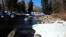
冬季的咆哮叉河,科罗拉多州伍迪溪
| Roaring Fork River 咆哮叉河 | |
|---|---|
 | |
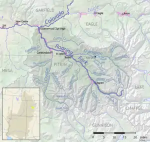 咆哮叉河水系图 | |
| 国家 | 美国 |
| 州 | 科罗拉多州 |
| 流域 | |
| 源頭 | Independence Lake |
| - 位置 | 皮特金縣怀特河国家森林 |
| - 坐標 | 39°08′38″N 106°34′04″W[1] |
| - 海拔 | 12,490英尺(3,810米) |
| 河口 | 科罗拉多河 |
- 位置 | 加菲爾德縣格伦伍德斯普林斯 |
- 坐標 | 39°32′57″N 107°19′47″W[1] |
- 海拔 | 5,718英尺(1,743米) |
| 面積 | 1,453 sq mi(3,760 km2)[2] |
| 本貌 | |
| 長度 | 70 mi(110 km) |
| 流量 | |
| 特徵 | |
| 支流 | |
参考文献
This article is issued from Wikipedia. The text is licensed under Creative Commons - Attribution - Sharealike. Additional terms may apply for the media files.
