平底锅河
平底锅河(英語:)是咆哮叉河的一条支流,科罗拉多河的二级支流,位于美国科罗拉多州中西部,长约42英里(68)[3],大部分位于怀特河国家森林境内,建有蓄水量102,000英畝·英尺(126,000,000立方)的Ruedi水库[4] 。

平底锅河上的Ruedi水库
| Fryingpan River | |
|---|---|
 Ruedi大坝下游的平底锅河 | |
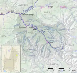 咆哮叉河水系图,包括平底锅河 | |
| 国家 | 美国 |
| 州 | 科罗拉多州 |
| 流域 | |
| 源頭 | Mount Massive附近 |
| - 位置 | 皮特金縣Hunter-Fryingpan Wilderness |
| - 坐標 | 39°09′52″N 106°31′40″W[1] |
| - 海拔 | 12,083英尺(3,683米) |
| 河口 | 咆哮叉河 |
- 位置 | 伊格爾縣玄武岩 |
- 坐標 | 39°22′00″N 107°02′03″W[1] |
- 海拔 | 6,591英尺(2,009米) |
| 面積 | 237 sq mi(610 km2)[2] |
| 本貌 | |
| 長度 | 42 mi(68 km)[3] |
| 流量 | |
| 特徵 | |
| 支流 |
|
参考文献
- . 美国地质局地理名称信息系统. [2011-01-27].
- (PDF). National Water Information System. U.S. Geological Survey. 1969–2013 [2016-06-01]. (原始内容存档 (PDF)于2016-06-25).
- U.S. Geological Survey. National Hydrography Dataset high-resolution flowline data. The National Map WebCite的存檔,存档日期2012-04-05, accessed March 18, 2011
- U.S Department of the Interior: "Water and Power resources Service, Project Data." U.S. Government Printing Office, 1981
This article is issued from Wikipedia. The text is licensed under Creative Commons - Attribution - Sharealike. Additional terms may apply for the media files.
