西海水闸
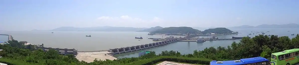
西海水闸,又名:南浦水闸,是朝鲜大同江出海口上修建的一座防潮堤,位于南浦特別市以西15公里[1]。水闸将大同江与黄海隔开,大堤长8公里,有三道船闸,可通过50,000吨级海轮。水闸建于1981年,举全国之力建设,至1986年竣工,约耗费40亿美元。此项水利工程的目标是为了阻挡黄海海水倒灌大同江[2][1][3],建立灌溉系统使得河口沿岸的土地适合耕种[1][2][4]。[5][6]
| 西海水闸 | |
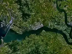 西海水闸的卫星地图。大同江在图中从右至左流向黄海,南浦市在河流北岸。 | |
| 语名稱 | |
|---|---|
| 諺文 | |
| 汉字 | |
| 文观部式 | |
| 马-赖式 | |
朝鲜官方将此工程视做本国建设的主要成就之一[7],经常作为电视新闻播报的背景画面出现。它也是国际旅行团的行程安排中的常见景点。坝顶铺有公路连接两岸,与大坝相连小岛上建有游客中心,为游人播放介绍该工程的多国语影片。
参考资料
- . 地理教师网. 2010-01-29 [2018-10-05]. (原始内容存档于2018-10-06).
- . mafengwo.cn. [2018-10-05].
- "West Sea Barrage", TAEHA. "The Taedong River, before the barrage was built, could not be used for agriculture and industry because it would become salty by the rising tide."
- Democratic People´s Republic of Korea - Geography, climate and population 的存檔,存档日期2011-10-29., Food and Agriculture Organization of the United Nations, 2010, Retrieved 2011-05-03
- . aljazeera.net. 2018-06-07 [2018-10-05].
- North Korea 的存檔,存档日期2011-08-06., Travel the Whole World, Retrieved 2011-05-03
This article is issued from Wikipedia. The text is licensed under Creative Commons - Attribution - Sharealike. Additional terms may apply for the media files.