虎門
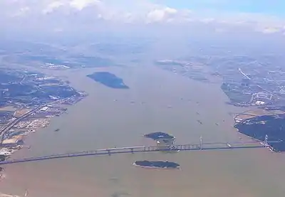
虎门是珠三角的狭长的海峡,處於珠江的南中國海入海口附近的狮子洋與伶仃洋交界處。虎門東側是穿鼻和亞娘鞋(威遠),西側是大角頭。[1]1839年3月,湖廣總督兼欽差林則徐到虎門銷煙。[2]1997年,跨越虎門的虎门大桥建成。
| 虎門 | |||||||||||||
 跨越虎門的虎門大橋 | |||||||||||||
| 繁体字 | |||||||||||||
|---|---|---|---|---|---|---|---|---|---|---|---|---|---|
| 简化字 | |||||||||||||
| 郵政式拼音 | Hu-mun | ||||||||||||
| 字面意思 | The Tiger Gate | ||||||||||||
| |||||||||||||
历史

1830年,清朝画家顺呱所作的有關虎門的繪画

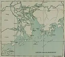
珠江三角洲的英文地图,其中虎門顯示為“Boca Tigris”
虎門在广州對海,清朝重兵防守,並設有包括虎门炮台在內的八座炮台。[7]在1809年9月至1810年1月之间,驻澳门的葡萄牙海軍战舰在虎門之戰中击败了一批滿清海盗。1839年3月,湖廣總督兼欽差林則徐到虎門銷煙。[2]在1839年11月3日的英清之间的穿鼻之战也位於虎門附近。而後在1841年1月7日又發生第二次穿鼻之戰,2月23日至26日虎门之战中英軍占领了虎门要塞。在1847年4月2日英国西江远征期间,虎門附近的炮台再次被英軍攻佔。在第二次鸦片战争中,英国在1856年的虎門之戰中又一次佔領了這些炮台。
地理
虎门港
東莞市虎门镇的虎门港是珠江三角洲的重要物流枢纽之一。它分为五个区域:
- 沙田港区
- 麻涌港区
- 沙角港区
- 长安港区
- 内河港区
该港口有72 km2(28 sq mi)水域和32 km2(12 sq mi)管辖区域。主要航道为13.5米(44英尺)深。[8]虎門港原名太平港。1983年,国务院批准太平港對外開放。1997年6月太平港与沙田港合并,更名为虎门港。[9]
另見
- 五口通商附粘善後條款(1843)
備註
- Bingham, J. Elliot (1843). Narrative of the Expedition to China from the Commencement of the War to Its Termination in 1842 (2nd ed.). Volume 2. London: Henry Colburn. p. 3.
- 施仲謀; 杜若鴻; 鄔翠文 (编). (PDF). 中華書局(香港). 2013: 166-173.
- Wathen, James. . London: J Nichols, Son and Bentley. 1814: 177.
- Hawks, Francis L.; Perry, Matthew (1857). Narrative of the Expedition of an American Squadron to the China Seas and Japan. New York: D. Appleton and Company. p. 161.
- Taylor 1898, p. 277
- Bernard, William Dallas; Hall, William Hutcheon (1846). The Nemesis in China (3rd ed.). London: Henry Colburn. p. 81.
- Waley, Arthur (1958). The Opium War Through Chinese Eyes. Woking, Surrey: George Allen and Unwin. ISBN 0049510126. pp. 130, 139.
- . [2020-02-24]. (原始内容存档于2014-06-03).
- Yeung, Godfrey (2001). Foreign Investment and Socio-Economic Development: The Case of Dongguan. New York: Palgrave. p. 97. ISBN 9780333978115.
参考文献
- Taylor, Isaac (1898). Names and Their Histories: A Handbook of Historical Geography and Topographical Nomenclature (2nd ed.). London: Rivingtons.
This article is issued from Wikipedia. The text is licensed under Creative Commons - Attribution - Sharealike. Additional terms may apply for the media files.
