柳營區
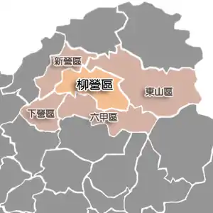
柳營區(臺灣話:)位於臺灣臺南市北部,屬於大新營生活圈的一部分。此區北臨新營區、東山區,南接六甲區、下營區,地處平原與山地交界地帶,西半部地勢平坦,東半部則屬丘陵地形,急水溪、龜重溪流經區境北端,氣候屬熱帶季風氣候,地方產業以酪農業為主。近年興建柳營科技工業暨環保園區有助於地方工業發展,及當地設有柳營奇美醫院提供醫療服務。

柳營區市區
| 柳營區 Liouying District[1][2][3][4][5] | |
|---|---|
| 市轄區 | |
 柳營區位於臺南市內北部 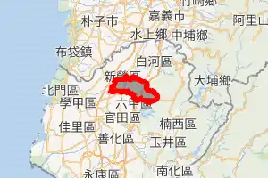
| |
| 上級行政區劃 | 臺南市 |
| 舊稱 | 查某營、查畝營 |
| 區劃 | 13里146鄰 |
| 政府 | |
| – 區長 | 汪慶龍(柳營區區長列表) |
| 總面積 | 61.2929平方公里 |
| 平均海拔 | 33 米 |
| 人口 | |
| – 總數 | 20,822人(2021年1月) |
| – 排名 | 27 |
| – 戶數 | 7,997戶 |
| 郵政編碼 | 736 |
| 戶政資料代碼 | 67000040 |
| 毗鄰 | 新營區、下營區、六甲區、東山區 |
| 網站 | http://www.liouying.gov.tw/ |
 柳營區位置圖 | |

柳營區公所
歷史
柳營區舊名「查畝營」(臺灣話:),鄭成功軍隊編制與「二十八宿」相同,「查畝營」應為「女宿鎮」屯營之地,故俗稱「查某營」,後演變為「查畝營」。而「柳宿鎮」軍團屯營之地可能與「女宿鎮」屯營之地毗鄰,故此兩鎮屯營之地合稱為「柳營」;二說是因明鄭時期在此設置查測田畝的軍營而得名,日治時期當局認為「查畝營」地名不雅,便以此地居民姓氏大宗的劉姓,取日語音譯為「柳」,易名為「柳營」。
1920年臺灣地方改制,在此地設置「柳營」,劃歸臺南州新營郡管轄,戰後改設臺南縣柳營鄉。2010年12月25日,因臺南縣市合併為直轄市而改稱柳營區。
歷任首長
鄉長
| 屆次 | 姓名 | 備註 |
|---|---|---|
| 1 | 劉偉 | |
| 2 | 劉敏樹 | |
| 3 | 陳庚金 | |
| 4 | 劉杭 | |
| 5 | 蔡木春 | |
| 6 | 蔡木春 | |
| 7 | 劉鹵 | |
| 8 | 廖振霖 | |
| 9 | 林百川 | |
| 10 | 黃國安 | |
| 11 | 邱等鴻 | |
| 12 | 黃國安 | |
| 13 | 黃國安 | |
| 14 | 吳金松 | |
| 15 | 黃國安 | 解職 |
| 15 | 吳金松 | 補選 |
區長
| 任次 | 姓名 | 備註 |
|---|---|---|
| 1 | 吳金松 | |
| 2 | 李添財 | |
| 3 | 李宗翰 | |
| 4 | 汪慶龍 |
行政區劃
2018年1月29日因里鄰調整,調整了光福里與中埕里之間的里界[7]。經此調整後,柳營區底下仍設13里:
人和里、士林里、八翁里、東昇里、光福里、中埕里、太康里、重溪里、神農里、篤農里、大農里、果毅里與旭山[8]。
人口
| 歷史人口 | ||
|---|---|---|
| 年份 | 人口 | ±% |
| 1981 | 25,953 | — |
| 1986 | 24,844 | −4.3% |
| 1991 | 24,420 | −1.7% |
| 1996 | 24,857 | +1.8% |
| 2001 | 24,124 | −2.9% |
| 2006 | 23,463 | −2.7% |
| 2011 | 22,443 | −4.3% |
| 2016 | 21,520 | −4.1% |
| 來源: . 內政部. (原始内容存档于2014-10-26). | ||
歷年人口變化
|
教育

柳營果毅國小
大專院校
高級中學
國民中學
醫療
交通
公車資訊
| 編號[10] | 路線 | 營運單位 | 備註 |
|---|---|---|---|
| 黃幹線 | 白河轉運站-新營-柳營-下營-麻豆轉運站 | 新營客運 興南客運 |
|
| 黃幹線 區間車(南) | 新營-柳營-下營-麻豆轉運站 | 新營客運 |
|
| 黃1 | 新營-柳營-林鳳營火車站-六甲 | 新營客運 |
|
| 黃2 | 新營-柳營-林鳳營火車站-六甲-王爺宮 | 新營客運 |
|
| 黃3 | 新營-柳營-二重溪-果毅後廟前 | 新營客運 |
|
| 黃4 | 新營-柳營-二重溪-果毅後-六甲 | 新營客運 |
|
| 黃5 | 新營-柳營-紅毛厝-下營廟前 | 新營客運 |
|
| 黃16 | 白河商工-白河轉運站-東山-六甲-隆田火車站 | 新營客運 | |
- 公路客運
| 編號 | 路線 | 營運單位 | 備註 |
|---|---|---|---|
| 7229 | 嘉義-水上車站-後壁-新營-柳營奇美醫院 | 嘉義客運 | |
旅遊

柳營區代天院
參考來源
- . Tainan City Government Global Website. 2016-06-03 [2019年11月22日] (英语).
Liouying District Office
- . LIOUYING District Office, Tainan City. [2019年11月22日] (英语).
I was lucky to have the opportunity to serve in Liouying district. Liouying is a cultural and beautiful place with industrial areas, scenic attractions, and professional agricultural /dairy area, there are so many wonderful things, yet we must work together to explore and experience it to make us feel more successful and rich at heart.
- Chia-Hao Chang (張家豪) Chiou-Shann Fuh (傅楸善) Shi-Wei Wang (王熹偉). (PDF): 3,4,5. 2017 [2019年11月22日] (英语).
Fig. 5: Farm field and ground truth polygons data in Liouying District.{...}Because of the Liouying District, Tainan County is located in the second swath of SAR image data used in this paper, we only processed these swaths of SAR SLC image data into backscatter image.{...}Fig. 8: Backscatter images combination and overlap with Liouying District.{...}Farmers mostly start to transplant rice in January in Liouying District, so that the backscatter feature are similar to water body in February.{...}To understand the temporal LBP of rice pixel, we subset three different image chips of rice growing area around Liouying District with VH and VV polarization backscatter.{...}The 1st rice season in Liouying District mostly starts to transplant rice in January and harvester in June.{...}But some error classified fields still there, such as some light blue polygons with red boundary in the middle part of Liouying Dist.
- . Chi Mei Medical Center. [2019年11月22日] (英语).
Taikang Vil., Liouying Dist., Tainan City 73657 Taiwan (R.O.C.)
- Liouying (Variant - V)位于GEOnet名称服务器的结果, United States National Geospatial-Intelligence Agency
- 廖銘瑞. . 壹凸新聞. 2009-04-24 [2016-05-30]. (原始内容存档于2017-03-05) (中文(台灣)).
- . 臺南市里鄰編組及調整專區. 臺南市政府. [2018-10-28].
- 柳營區公所 - 村介紹 的存檔,存档日期2011-05-19.
- (XLS). 2020-02-10. 已忽略未知参数
|publiser=(建议使用|publisher=) (帮助) - . [2017-11-18]. (原始内容存档于2016-07-28).
This article is issued from Wikipedia. The text is licensed under Creative Commons - Attribution - Sharealike. Additional terms may apply for the media files.
